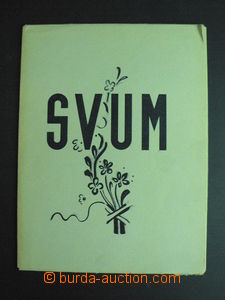
1939 collection 20 original lithography, Association creative artists Moravian in/at Hodonín, issued by SVUM as členskouprémii, format prints A4; good condition
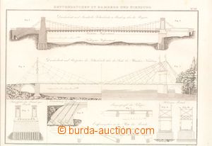
1830 comp. 2 pcs of technických drawings, picture insert mechanics, Kettenbrücken zu Bamberg and Nienburg, über die Seine in Paris (chain bridges), format A3, stains in margin
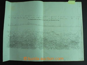
1845atlas 3 maps with úseky railway tracks Olomouc–Praha with marked profilem track, technical drawings portálů tunnels, plans railway yard on/for railway-stations in Prague, Pardubice, Zábřeh, Mohelnici; folded to format A3, good condition, interesting not only for lovers railways
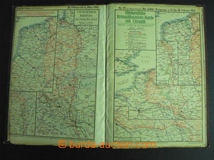
1916 Die militärischenEreignisse im Völkerkrieg 1914-16 (military event/-s in/at WWI.), 3ter Volume, Kriegshilfe, München (Munich), atlas with 30 maps bojišť and description; have/has signs of usage, 1 map damaged
1845map Olomouckého district Margravate Moravian, issued in Olomouc, folded, divided on/for two parts underglued on canvas in/at carton cover, very good condition
1901 WIEN, Freytag'sVerkehrsplan (transport town map Wien (Vienna)), scale 1:15.000, format map/-s 72x76cm, contains also list streets; frayed envelope in margins
1930-41collection 5 pcs of maps, 1x Krkonoše 1:50.000 (1946) issued Neubert, large format, 1x school map Protectorate, used, 1x school map Czechoslovakia incl. Carpathian Ruthenia, used, 1x big map Czechoslovakia incl. Carpathian Ruthenia (viewing of quality recommended), 1x komunikační map No. 6 issued Automobile club Republic of Czechoslovakia (Brno to Třebíč), good quality, all folded
1910?railway map Austria Hungary with návazností tracks on/for surrounding states, large format 110x84cm, folded, color, inside clear, small prodřeniny, overall preserved and well readable, suitable for specialist
1930-56 Map SchematycznaSieci P. K. P., comp. 3 pcs of maps railway net Poland (46x42cm) and 2x Austria (40x22cm, A5); folds, Austria with spot and tearing L margins (15mm), else preserved
1948 Carte des Lignes S. N. C. F., comp. 2 pcs of maps French railway net, map Europe, 7 plans towns and regions, advertising, formáty: 47x31cm and 39x39cm; folds, good condition
1952Übersichtskarte zum Reichsbahngüterkursbuch, přehledná map freight railway net GDR (55x66cm) and smaller map Deutsche Bundesbahn with marking main tracks; folds, good condition
1958Übersichtskarte zum amtlichenKursbuch der Deutschen (German) Bundesbahn, wall map railway net in/at Západním Germany, scale 1:1.450.000, format 61x77cm; folds, very good condition
1912Album town Kroměříž, issued in memory of Czech lékárnické company, publication in hard cover with much pictures town (Jewish St.) and with introductory pasáži about/by lékárnách town; good condition
1925 Czechoslovak Chicago and surroundings (by E. F. Mácha, Chicago), 175 krásných Ppc with descriptions in Czech, předmluva V. Balvina, 20 sheets sešitých to booklet/-s postcard format, good condition, interesting example of aktivitě Czechoslovaks in USA
1929Kalus Joseph: Valašský King, xylographs JožkyBarucha, issued J. Hladký, Hranice, printing 50 pcs of on hand-made paper, signatures of authors, number copy/imprint 34
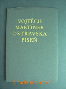
1929 Martínek Vojtěch:Ostravská song, xylographs FerdišeDuši, issued J. Hladký, Hranice, printing 150 copies/imprints on hand-made paper, copy No. 20, signatures of author and výtvarníka, very fine