warning
This auction is archived, you cannot bid or buy items from this auction!
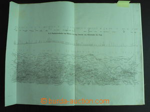
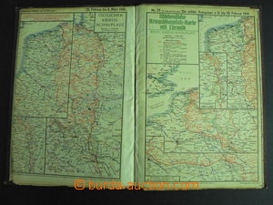
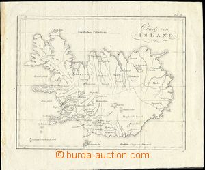
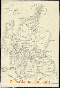
1845 atlas 3 maps with úseky railway tracks Olomouc–Praha with marked profilem track, technical drawings portálů tunnels, plans railway yard on/for railway-stations in Prague, Pardubice, Zábřeh, Mohelnici; folded to format A3, good condition, interesting not only for lovers railways 1916 Die militärischen Ereignisse im Völkerkrieg 1914-16 (military event/-s in/at WWI.), 3ter Volume, Kriegshilfe, München (Munich), atlas with 30 maps bojišť and description; have/has signs of usage, 1 map damaged 1800 map Iceland, format 25x21cm, folds, stains in L margin 1800 map Scotland, format A4, folds 1819 by hand drawn map combat position 5. artillery regiment, format 23x17cm, folded, well preserved 1845 map Olomouckého district Margravate Moravian, issued in Olomouc, folded, divided on/for two parts underglued on canvas in/at carton cover, very good condition 1901 WIEN, Freytag's Verkehrsplan (transport town map Wien (Vienna)), scale 1:15.000, format map/-s 72x76cm, contains also list streets; frayed envelope in margins 1930 CARPATHIAN RUTHENIA, 4 pcs of automap issued Autoklubem Republic of Czechoslovakia, měř. 1:200.000, No.23, 24, 28 and 29, complete territory Carpathian Ruthenia, excellently good condition, original covers, extraordinary offer 1930-41 collection 5 pcs of maps, 1x Krkonoše 1:50.000 (1946) issued Neubert, large format, 1x school map Protectorate, used, 1x school map Czechoslovakia incl. Carpathian Ruthenia, used, 1x big map Czechoslovakia incl. Carpathian Ruthenia (viewing of quality recommended), 1x komunikační map No. 6 issued Automobile club Republic of Czechoslovakia (Brno to Třebíč), good quality, all folded 1943 air map RAF 1:500.000, Leipzig, 84x64cm, good condition 1910? railway map Austria Hungary with návazností tracks on/for surrounding states, large format 110x84cm, folded, color, inside clear, small prodřeniny, overall preserved and well readable, suitable for specialist U:A5
1930-56 Map Schematyczna Sieci P. K. P., comp. 3 pcs of maps railway net Poland (46x42cm) and 2x Austria (40x22cm, A5); folds, Austria with spot and tearing L margins (15mm), else preserved 1948 Carte des Lignes S. N. C. F., comp. 2 pcs of maps French railway net, map Europe, 7 plans towns and regions, advertising, formáty: 47x31cm and 39x39cm; folds, good condition U:A3v–
1950 Carta Ferroviaria d'Italia, map Italian railway net with plans 11 towns or regions, 55x64cm, folds, preserved 1952 British Railways, railway map Brit. railway net, 38x61cm, folds, preserved 1952 Übersichtskarte zum Reichsbahngüterkursbuch, přehledná map freight railway net GDR (55x66cm) and smaller map Deutsche Bundesbahn with marking main tracks; folds, good condition 1956 Rutebok for Norge, big wall map transport net in Norway, scale 1:1.000.000, format 76x110; folds, very good condition 1958 Übersichtskarte zum amtlichen Kursbuch der Deutschen (German) Bundesbahn, wall map railway net in/at Západním Germany, scale 1:1.450.000, format 61x77cm; folds, very good condition 1936 Berlin olympic stadium, guide with plánkem and airmail postcard areálu, perfect condition 1912 Album town Kroměříž, issued in memory of Czech lékárnické company, publication in hard cover with much pictures town (Jewish St.) and with introductory pasáži about/by lékárnách town; good condition 1925 Czechoslovak Chicago and surroundings (by E. F. Mácha, Chicago), 175 krásných Ppc with descriptions in Czech, předmluva V. Balvina, 20 sheets sešitých to booklet/-s postcard format, good condition, interesting example of aktivitě Czechoslovaks in USA 1940 Zlín in photograph, folder with 21 photos, issued by Tisk-publishing in Zlín, recess printing; light frayed envelope, stain on envelope U:A5
1955 Anders J., Vorel S.: Vodácká map Vltava, issued ÚSGK, 72 sides, 33 maps, úseky Czech Krumlov–Praha-Braník; frayed envelope 1913 Baedeker Karl: Süddeutschland, Guide für Reisende, Leipzig, 538 sides, 59 maps, 50 plans, 13 nákresů, pocket issue, have/has signs of usage, but else preserved