warning
This auction is archived, you cannot bid or buy items from this auction!
1863 map Moravia, folded map, scale 1:288.000, format 104x83cm, underglued by fabric, in folds partly detached, easily repairable U:O4
1870 marine special map surroundings jaderského island Meleda (Mljet), folded on/for A5, 18 parts, underglued cloth, general format 75x59cm, B/W, well preserved U:O5
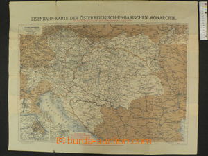
1904 railway map Austria-Hungary, format 80x64; folds, partially torn in fold U:A3s|
1914? war map No.17 (Dolomity, Alps, upper Italy and surroundings), folded on/for A5, 32 parts, color, textile podlepení, general format 94x70cm, scale 1:250.000, nice, profitable offer U:O5
1929 comp. 2 pcs of maps, Brno, format 60x63cm, scale 1:11.520, folded, frayed margins; Brno political district, format 50x43cm, scale 1:90.000, folded, very good condition U:O4
1930 Plan de Paris, podzemní track, network lines, format 49x32cm, Czech - French - German text, rates, station, folded into pocket size, short tear in fold U:A5
1930? comp. 3 pcs of maps, Carpathian Ruthenia 2x, formats 52x39cm and 37x56cm, both scale 1:200.000, Moravian-Silesian country, Fastr's road map, 57x44cm, scale 1:500.000, 2x underglued by fabric, 1x in folds detached and repaired U:O4
1938 Česko-slovenská republic, so-called. Druhá republic, format 97x47cm, scale 1:1.000.000, short tear in fold, otherwise preserved U:O4
1938 map Czech Republic - Slovakia, without annexed territory, drawn with typical coats of arms figures, products and objektů in/at region, color, in corner printing advertising radiové vysílání, large format 122x73cm, folded on/for smaller size, hints of hanging out, damaged nepotištěné margins (can be odřízout), on reverse by pencil child notice and printings on/for two dílcích, map is clear, well readable, short period her validity, rare, it is worth seeing U:A3s|
1938 railway map Czechoslovakia, advertising Vágner in Brno + table postal sazeb, format 94x43cm, scale 1:1.000.000, preserved, also with 2x pocket riding Order, 1940 and 1944, good condition U:O5
1940 Protectorate Bohemia and Moravia, big wall map, secondary map Prague, format 95x58cm, scale 1:500.000, good condition U:O4
1942 Greater German Reich, BOHEMIA-MORAVIA, General Government, Slovakia and Switzerland, wall map, format 95x80cm, scale 1:1.500.000, worn through in fold U:O4
1943 Der deutsche Osten and Poland, wall map, format 75x75cm, scale 1:2.000.000, underglued in folds, tearing in fold U:O4
1948 PRAGUE, detailed plan main town, 36 sheets, scale 1:15.000, Melantrich, light damaged wrapping U:O5
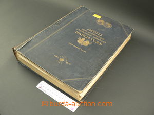
1909 Andrees neuer allgemeiner and österreichisch-ungarischer Handatlas, 147 main maps, copper print, 163 side maps and plans, 223 sides, 2. issue, Wien, well preserved U:Z
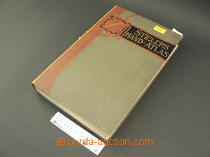
1914 Stielers Hand-Atlas, 100 main maps, copper print, 162 side maps and plans, 240 sides, 10. issue, Gotha, nádherná Art Nouveau binding, kožený backbone, well preserved U:Z
1935 Handbook for zákazníky f. Avion, olejářská community, Brno, information for motoristy, road map/-s, vzdálenosti, regulations etc.., pocket issue, good condition U:O4
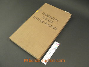
1939 Handatlas für die Hitler-Jugend, Volk and Reich Verlag Ltd., Berlin, 60 mapových sheets, 102 sides rejstříku, in good condition U:Z
1899 NÁCHOD - album town Náchod, drew John Dobeš, 25 paintings, synagogue, brewery, factory and oths., good condition U:O4
1885 illustrated guide Alpen-Gebiet, Hartleben's Verlag, Wien, 324 sides, 130 illustration, 13 maps, pocket format, good condition U:Z
1900-10 comp. 4 pcs of Körbrových tourist guides, notebook No.1 Karlštejn (castle), No.4 Štěchovice and St. John's Rapids, No.6 Česko-saské Switzerland and No.8 Tábor and Bechyně, good condition U:O5
1910? illustrated guide Österr.. Staatsbahnen, Linz–Salzburg, 124 sides, 56 illustration, maps and maps, pocket format, in good condition U:O5