warning
This auction is archived, you cannot bid or buy items from this auction!
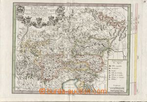
1769 general chorografická map Austria and okolních countries, Chorographie du Cercle D´Autriche, according to Vischera, Hubnera and Mayera, French edition Phillipe Buache, copperplate 40x29cm, incl. Bohemia and Moravia, L at top Austrian country coats of arms, contemporary color marking border, graphically very decorative and in perfect quality, atypical map! U:A3s|
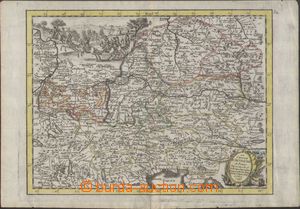
1745 MAPA RAKOUSKA and okolních countries, Le Cercle d´Autriche, G. L. Le Rouge, copperplate 26x19,5cm, incl. Bohemia and Moravia, L at top scene from combat scény, contemporary color marking border, graphically very decorative, very good condition U:A3s|
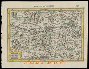
1607 MAPA RAKOUSKA Austria Archiduc., Gerard Mercator, issue evidently John Jansson older "Atlas Minor", copperplate 19x 13cm, Amsterdam, French version, dobově colored, very fine stav U:A4
1628 MAPA RAKOUSKA Austria Archiducatus, Gerard Mercator, issue evidently John Jansson older "Atlas Minor", copperplate 19x14cm, Amsterdam, holandská version, dobově colored, perfect condition; Mercatorovy mědiryty belongs to nejvýznamnějším dílům from whole history kartografie U:A4