warning
This auction is archived, you cannot bid or buy items from this auction!
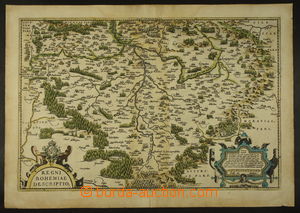
1568-75 ORTELIUS ABRAHAM - MAPA ČESKÉHO KRÁLOVSTVÍ with měřítkem and kartuší with text about/by size territory, in Latin, according to Joh. Crigingera (Prague 1568), used Orteliem in/at his atlasu Theatrum Orbis Terrarum; colored copperplate on hand-made paper, size 39,5 x 55cm, folded, lower little underglued, rare! U:A3s|
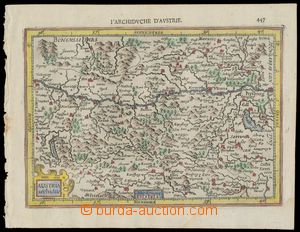
1607 MAPA RAKOUSKA Austria Archiduc., Gerard Mercator, issue evidently John Jansson older "Atlas Minor", copperplate 19x 13cm, Amsterdam, French version, dobově colored, very fine stav U:A4
1628 MAPA RAKOUSKA Austria Archiducatus, Gerard Mercator, issue evidently John Jansson older "Atlas Minor", copperplate 19x14cm, Amsterdam, holandská version, dobově colored, perfect condition; Mercatorovy mědiryty belongs to nejvýznamnějším dílům from whole history kartografie U:A4
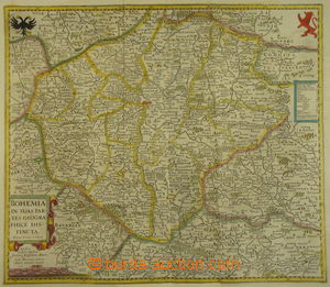
1640 MAPA ČESKÉHO KRÁLOVSTVÍ map of Bohemia, author John Janssonius (1588-1664), colored gravure 40x64,5cm, French text on the reverse side; well in good condition piece, interesting U:A0
1650 CHEB map town Cheb (Eger), copperplate, with German legendou, author M. Merian, size 36x32cm; very good condition good condition U:A3s|
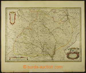
1650? KOMENSKÉHO MAPA MORAVY map March of Moravia John Amose Comenius according to his original gravure, author Johannes Jansonius (1588-1664), colored gravure 59x50cm, on the reverse side latinský text; well dochovaný piece, lower underglued, interesting! U:A0
1654 MAPA MARKRABSTVÍ MORAVSKÉHO, SLEZSKÉHO KNÍŽECTVÍ A LUŽICE colored map, author Nicolas Sanson (1660-1667), gravure 54x43cm, paper with vodoznakem; at top cutting, otherwise very good condition U:A0
1700-1707 BRNO map obléhání town Brno Švédy in 1645 after/behind Třicetileté war, copperplate with German text and legendou, details trenches and fort Špilberk; author M. Merian, in passe-partout, size 41x31cm, only small tearing in margin, otherwise perfect condition, extraordinary offer! U:X
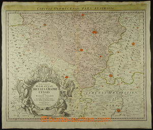
1715-1730 MAPA OLOMOUCKÉHO KRAJE map Olomouckého district in/at Margravate moravském, author Johann Homann (1664-1724), colored gravure 52x60,5cm, without text on the reverse side; well in good condition piece, lower smaller thin place in paper, interesting U:A0
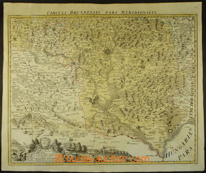
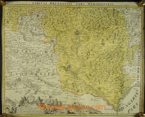
1720 MAPA BRNĚNSKÉHO KRAJE map Brněnského district in/at Margravate moravském, author Johann Christoph Müller (1673-1721), Johann Homann (1664-1724), gravure 63x53cm, without text on the reverse side; well in good condition piece, interesting U:A0
1728 MAPA BRNĚNSKÉHO KRAJE map Brněnského district in/at Margravate moravském, author Johann Christoph Müller (1673-1721), Johann Homann (1664-1724), gravure 47x58cm, without text on the reverse side; in good condition piece U:A0
1743 MAPA ČESKÉHO KRÁLOVSTVÍ A MAPA MARKRABSTVÍ MORAVSKÉHO issue Le Rouge, gravure, 2 map/-s, size 19,5x26cm; very in good condition condition U:A3s|
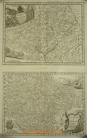
1745 MAPA RAKOUSKA and okolních countries, Le Cercle d´Autriche, G. L. Le Rouge, copperplate 26x19,5cm, incl. Bohemia and Moravia, L at top scene from combat scény, contemporary color marking border, graphically very decorative, very good condition U:A3s|
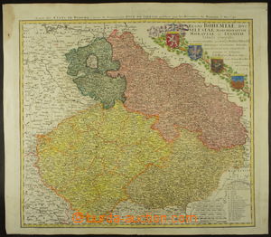
1748 MAPA ČESKÉHO KRÁLOVSTVÍ, MARKRABSTVÍ MORAVSKÉHO, SLEZSKÉHO KNÍŽECTVÍ A LUŽICE map Czech countries, according to original elaboration Joh. Homanna (1664-1724), colored gravure 60x53,5cm, without text on the reverse side; caption French, legenda in Latin, well in good condition piece, only smaller stain in L upper corner outside samotnou map U:A0
1758 MAPA MARKRABSTVÍ MORAVSKÉHO, color, author German engraver Tobias Conrad Lotter (1717-1777); size 52x50cm, marked single district and details Brno and Olomouc; very good condition U:A0
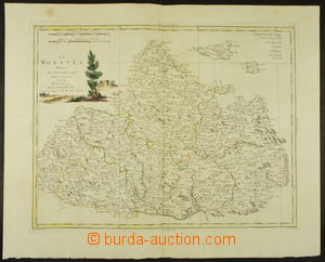
1779 MAPA MARKRABSTVÍ MORAVSKÉHO colored map, author Antonio Zatta, legenda psána Italian, gravure 40x31cm, paper with vodoznakem; very good condition U:A0
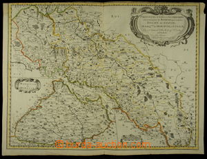
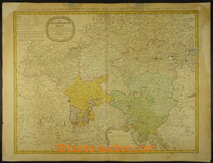
1788 HABSBURG MONARCHY - MAPA RAKOUSKÝCH ZEMÍ colored, according to original elaboration Joh. Homanna, at top French text; size 59x67cm, 2x abrasion in/at map, signs of age, interesting U:A0
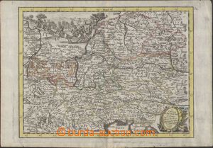
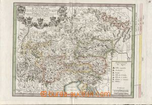
1769 general chorografická map Austria and okolních countries, Chorographie du Cercle D´Autriche, according to Vischera, Hubnera and Mayera, French edition Phillipe Buache, copperplate 40x29cm, incl. Bohemia and Moravia, L at top Austrian country coats of arms, contemporary color marking border, graphically very decorative and in perfect quality, atypical map! U:A3s|